


HYDRO-GIS: The GIS, hydrological, and hydraulic software for your needs
A comprehensive GIS software, ideal for hydrology and hydraulics professionals

Modern and Intuitive Graphical Interface
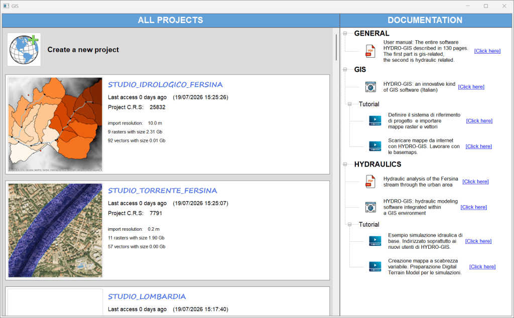
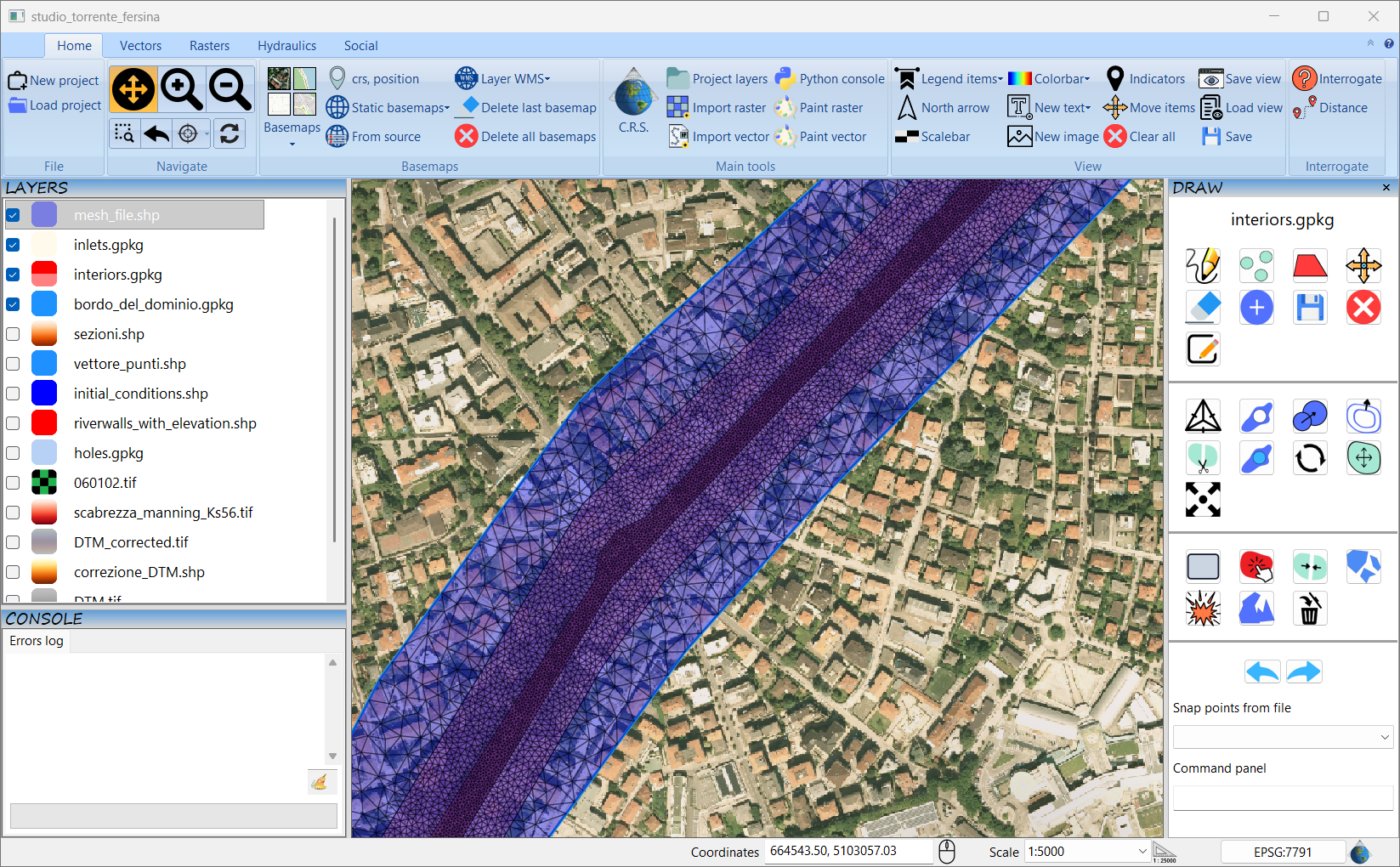
HYDRO-GIS offers a modern and user-friendly graphical interface, featuring a ribbon and drag & drop panel functionality. This cutting-edge design aligns with the standards of the most advanced GIS software, making the user experience intuitive and pleasant.
Features are logically organized, facilitating quick access to the necessary tools.
It is a complete GIS software
HYDRO-GIS is a GIS, hydrological, and hydraulic software.
As a GIS software, HYDRO-GIS excels in visualizing and processing geographic maps. Three of its four sections are dedicated to geographic map management, offering advanced features for both raster processing and vector calculations.
A key strength is the use of a single coordinate reference system for each project, with maps stored in internal folders. This approach completely eliminates errors and malfunctions related to coordinate systems, moving or deleting maps, and lack of permissions—common issues in other GIS software.
HYDRO-GIS guarantees high performance, displaying large raster and vector maps smoothly, without temporary layer disappearances. Additionally, it allows you to easily download online maps, including basemaps and WMS/WFS layers, improving your workflow efficiency.
Every software window includes a concise explanation of the available operations and parameters, providing built-in assistance that makes learning and using the features easier. A dedicated map composition section allows you to create professional maps simply and intuitively.
By relying on third-party Python libraries, HYDRO-GIS ensures security and reliability, backed by active developer communities.
Related articles: https://hydro-gis.com/2023/11/09/hydro-gis-innanzitutto-un-software-gis/
Supported raster operations:
Merge, clip, format conversion, reprojection, extraction, raster calculator (mathematical, conditional, and index operations on/between rasters), geomorphological analysis: contours, slope, aspect, hillshade, roughness, Topographic Ruggedness Index (TRI), Topographic Position Index (TPI); 3D raster plot, reclassification, rasterization, statistics extraction, “no-data” management, elevation profile, distance from source (proximity), etc…
Supported vector operations:
Merge (concat), clip, reprojection, extraction, overlay (union, difference, intersection, symmetrical difference), spatial join (sjoin), attribute join (merge), vectorization, statistics, raster statistics within vector geometries, new vectors, attribute table, import from .CSV, import from .DXF, point sampling, etc…
Geometric operations (buffer, centroids, simplify geometry, dissolve, …) and advanced vector drawing, etc…
Advanced Hydrological Section
HYDRO-GIS integrates a dedicated hydrology section, leveraging the raster and vector maps present in the project. This section allows you to perform advanced hydrological analyses directly within the software.
Basic features include pit-filling, drainage network and sub-basin extraction, as well as floodplain identification. For a more in-depth hydrological study, HYDRO-GIS allows you to calculate the flood hydrograph at a river cross-section.
Two models are available for hydrological modeling:
- Advanced Hydrological Model: Includes Kriging for rainfall data spatialization, the SCS (Soil Conservation Service) model for rainfall separation, and the geomorphological model (GIUH-code) for routing precipitation to the basin outlet.
- Kinematic or Rational Model: A simple approach that requires no calibration, ideal for quick estimates.
Related articles: https://hydro-gis.com/2024/01/16/calcolo-dellidrogramma-di-piena-con-il-modello-cinematico-o-razionale-utilizzando-il-software-hydrogi/
Supported hydrological operations:
Pit-filler, drainage area extraction, drainage network extraction, floodplain identification, watershed extraction from a point and sub-basins, drainage path extraction and outlets points, kinematic (or rational) model, Kriging, SCS model, and geomorphological model (GIUH).

Integrated Hydraulic Section
The hydraulic modeling section of HYDRO-GIS allows you to simulate flood events in rivers and streams using the finite volume method on unstructured grids. Two models are supported:
- Fixed-bed model: For flood events with insignificant sediment transport, such as in valley floor rivers.
- Decoupled mobile-bed model: Ideal for river and torrential floods, allowing you to model changes in the riverbed.
HYDRO-GIS stands out for its ability to model a wide range of situations and hydraulic structures through simple operators. Precise control over mesh size in different areas of the domain improves accuracy in critical zones like the riverbed, banks, and flooded areas.
Integration into an advanced GIS-hydrological ecosystem allows you to manage the entire process, from input preparation to output visualization, within a single software. This optimizes your workflow and reduces the time and costs associated with using multiple tools.
Related article: https://hydro-gis.com/2024/09/27/hydro-gis-un-software-idraulico/
Supported hydraulic operations:
Fixed-bed model, mobile-bed model, results visualization, advanced visualization customization, 3D results, extraction of maximum depth maps, maximum velocity, and maximum and final erosion/deposition maps.

